The Forcellina and Lunghin Passes together build a crossroad with the Septimer Pass. The Forcellina Pass starts in the Avers Valley to end north of the culmination point of the Septimer Pass; the Lunghin Pass starts in the Engadin to reach a point slightly more to the north on the same pass. Like the Septimer Pass, they are a paradise for hikers and mountain-bikers.
 |
| Forcellina Pass |
The Forcellina Pass starts in Juf in the Avers Valley at 2126 m (7000 ft.). Juf is one of the highest permanently occupied villages in Europe. Since the Bronze Age and into the late 19th century, the pass was the main route into and out of the Avers Valley. This isolation kept the valley out of all wars ravaging Europe since the 16th century preserving many buildings from earlier centuries. A visit there is like going into a time capsule of the 14th century.
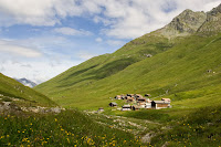 |
| Juf Avers |
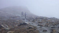
Ascending through the alpine meadows of the Avers, the pass culminates at 2672 m (8750 ft.) near Piz (pike) Forcellina which may be reached in an extra 30 minutes hike. From there, the pass descends to join the Septimer Pass a bit north of its culmination point. To continue from here, the choices are to follow the Septimer Pass south to the Bregaglia Valley or north to Bivio. On the way to Bivio, the Lunghin Pass will go off east towards the Engadin as well.
 |
| Forcellina Pass |
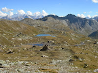
The Lunghin Pass ascends from the Septimer Pass to its culmination at 2645 m (8700 ft.) marked by Lake Lunghin. The lake sheds its water in three rivulets; one of them is the start of the Inn River that will later join the Danube and the water will eventually end up in the Black Sea; one will later join the Rhine River and its water will end up in the North Sea; and the last one runs off south towards lake Como and the Po River to end up in the Mediterranean. The lake is unique in the Alps as the only three way water divide.
 |
| Forcellina Pass |
From the lake, the pass descends through Alpine meadows to Maloja at 1815 m (6000 ft.). Though being a village the high plateau called the Engadin, Maloja forms part of Bregaglia and its population speaks Italian, not Romansh like the rest of the Engadin Valley. It is also the starting point of the Maloja Pass down into the Bregaglia Valley.
 |
| Lunghin Pass |
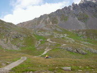
The road system of Lunghin, Forcellina, and Septimer Passes is well suited for hikers and mountain-bikers. The paths are well built and well kept and anybody who will manage a steep incline or two is able to enjoy the walks. There are some essentials a hiker has to think of taking along: excellent walking boots, warm clothing, food, and a water flask.
 |
| Lake Lunghin |
There are no hospices, kiosks, or shops along the passes; food for lunch is therefore essential. Water on the other hand is in ample supply and the water bottle may be replenished with the cleanest and best water all the time. The passes are so easy to walk that dogs can be taken along without a problem; they should be kept on leash in September, though, as the hunting season begins at that time.
 |
| Lunghin Pass |
Before starting, check the weather forecasts; in bad weather, temperatures may descend to freezing point even in summer. And don’t be afraid of having trouble finding help should you meet with a mishap or even accident, the walks are very popular and you’ll see people every few minutes. And as to etiquette on the paths: people greet each other; and as there are already three languages used locally, the language used is of no importance.
 |
| Lunghin Pass |
All the passes mentioned have been widely in use since at least the Bronze Age but probably longer. They were of importance to the Romans as main routes to the North of the Alps. Sometimes, Roman or earlier remains can be seen on and besides the current paths marking the passes. If you like walking with history, this is one of the must dos.
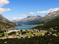 |
| Maloja |
Further reading


No comments:
Post a Comment